
approach
US /əˈprəʊtʃ/
UK /ə'prəʊtʃ/
- v.t./i.近づく;話を持ちかける
- n. (c./u.)目的に近づく方法 : 道;交渉しようとして人に近づくこと;取り組み方 : 扱い方
A2 初級TOEICもっと見るbring on
US /brɪŋ ɑn/
UK /briŋ ɔn/
- phr. v.起こす
A1 初級もっと見るcalm
US /kɑm/
UK /kɑ:m/
- adj.静かな;穏やかな;穏やかな
- v.t./i.落ち着かせる : 落ち着く
- v.i.静まる
- v.t.落ち着かせる
- n. (u.)凪
A2 初級もっと見るcatastrophic
US /ˌkætəˈstrɑfɪk/
UK /ˌkætə'strɒfɪk/
- adj.壊滅的な
B2 中上級もっと見るclimate
US /ˈklaɪmɪt/
UK /ˈklaɪmət/
- n. (c./u.)気候;雰囲気;気候帯
A2 初級もっと見るcolumn
US /ˈkɑ:ləm/
UK /ˈkɒləm/
- n. (c./u.)コラム;円柱;列;コラム;縦隊;列;柱状
B1 中級もっと見るcone
US /koʊn/
UK /kəʊn/
- n. (c./u.)円錐;明るい光と色を感じる網膜の視覚受容細胞;アイスクリームのコーン
B1 中級もっと見るcrucially
US
UK
- adv.極めて重要なこと
B1 中級もっと見るcuriosity
US /ˌkjʊriˈɑsɪti/
UK /ˌkjʊərɪ'ɒsətɪ/
- n. (c./u.)珍しい物;好奇心;珍しい物;詮索好き
B1 中級もっと見るcyclone
US /ˈsaɪkloʊn/
UK /ˈsaɪkləʊn/
- n. (c./u.)サイクロン;サイクロン;サイクロン;サイクロン式掃除機
C1 上級もっと見るdevastating
US
UK
- v.t.荒廃させている
- adj.壊滅的な;衝撃的な
B1 中級もっと見るdirection
US /dɪˈrɛkʃən, daɪ-/
UK /də'rekʃn/
- n. (c./u.)指示;方向;方向
A2 初級TOEICもっと見るdivide
US /dɪˈvaɪd/
UK /dɪ'vaɪd/
- v.t./i.割る;分ける;分配する;分裂させる;境界を定める;意見が分かれる
- n.境界
A2 初級TOEICもっと見るemphasize
US /ˈɛmfəˌsaɪz/
UK /'emfəsaɪz/
- v.t.強調する
B2 中上級TOEICもっと見るenormous
US /ɪˈnɔrməs/
UK /iˈnɔ:məs/
- adj.巨大な;莫大な;多大な
A2 初級もっと見るessential
US /ɪˈsɛnʃəl/
UK /ɪ'senʃl/
- adj.絶不必要な : 不可欠な;根本的
- n.精油
B1 中級TOEICもっと見るflood
US /flʌd/
UK /flʌd/
- v.t./i.溢れる;浸水する;溢れさせる
- n. (c./u.)洪水;人が押し寄せること;洪水;殺到;強光;感情の爆発
B1 中級もっと見るfor sure
US /fɔr ʃʊr/
UK /fɔ: ʃuə/
- adv.確かに;間違いなく
- interj.そのとおり
- phr.確かに;間違いなく
A2 初級もっと見るforecast
US /ˈfɔ:rkæst/
UK /ˈfɔ:kɑ:st/
- n. (c./u.)予測;天気予報;予測
- v.t./i.予測する;予測
B1 中級TOEICもっと見るgain
US /ɡen/
UK /ɡeɪn/
- v.t./i.増える;得る
- n. (c./u.)増加
A2 初級TOEICもっと見るhemisphere
US /ˈhɛmɪˌsfɪr/
UK /ˈhemɪsfɪə(r)/
- n. (c./u.)半球;半球;半球
B2 中上級もっと見るhistoric
US /hɪˈstɔrɪk, -ˈstɑr-/
UK /hɪˈstɒrɪk/
- adj.歴史的な;歴史的な
B1 中級もっと見るhurricane
US /ˈhɚrɪˌken, ˈhʌr-/
UK /'hʌrɪkən/
- n.ハリケーン
B1 中級もっと見るimpact
US /ˈɪmˌpækt/
UK /'ɪmpækt/
- n.影響;衝撃
- v.t./i.衝突する;影響を与える;埋伏する
A2 初級TOEICもっと見るjournalism
US /ˈdʒɜ:rnəlɪzəm/
UK /ˈdʒɜ:nəlɪzəm/
- n. (u.)ジャーナリズム
B2 中上級もっと見るlandfall
US /ˈlændˌfɔl/
UK /ˈlændfɔ:l/
- n.陸地初見
C1 上級もっと見るleave out
US /liv aʊt/
UK /li:v aut/
- phr. v.~し忘れる : 除外する
A1 初級もっと見るlook at
US /lʊk æt/
UK /luk æt/
- phr. v.見る;注目する;見る;調べる
A1 初級もっと見るmajor
US /ˈmedʒɚ/
UK /'meɪdʒə(r)/
- n. (c.)少佐;専攻;成人
- adj.メジャーリーグ;重要な;主要な;長調の
- v.i.専攻する
A2 初級TOEICもっと見るmoisture
US /ˈmɔɪstʃɚ/
UK /'mɔɪstʃə(r)/
- n. (u.)水蒸気 : 水分 : 湿気 : 湿度 : 蒸気
B1 中級もっと見るmove to
US /muv tu/
UK /mu:v tu:/
- phr. v.引っ越す
- v.t./i.取り掛かる
A2 初級もっと見るnewsroom
US /ˈnu:zru:m/
UK /ˈnju:zru:m/
- n.ニュース編集室
C2 上級もっと見るnortheast
US /nɔrθˈist, nɔrˈist/
UK /'nɔ:θ'i:st/
- n.北東
C2 上級もっと見るoccur
US /əˈkɚ/
UK /əˈkɜ:(r)/
- v.i.起こる;存在する;思い浮かぶ
A2 初級TOEICもっと見るon this side of
US /ɑn ðɪs saɪd əv/
UK /ɒn ðɪs saɪd əv/
- prep. phr.この側にある
B2 中上級もっと見るouter edge
US /ˈaʊtɚ ɛdʒ/
UK /ˈautə edʒ/
- n.外縁;外側のエッジ;限界
B1 中級もっと見るpotential
US /pəˈtɛnʃəl/
UK /pəˈtenʃl/
- adj.可能性がある;潜在的な
- n. (u.)可能性
- n. (c./u.)可能性;潜在能力;候補者;ポテンシャル
A2 初級TOEICもっと見るquadrant
US /ˈkwɑ:drənt/
UK /ˈkwɒdrənt/
- n. (c./u.)四分円;四分儀
C1 上級もっと見るradar
US /ˈredɑr/
UK /ˈreɪdɑ:(r)/
- n.レーダー
B2 中上級もっと見るrather than
US
UK
- adv.どちらかといえば;むしろ
- prep.~よりむしろ
A1 初級もっと見るreach
US /ritʃ/
UK /ri:tʃ/
- v.t./i.到着する;届く;手を伸ばす
- n. (u.)権力の及ぶ領域
A2 初級TOEICもっと見るrotate
US /ˈroʊteɪt/
UK /rəʊˈteɪt/
- v.t./i.交替する;〈作物を〉輪作する;交替する;場所を交替する;人が交替する;回転する
B2 中上級もっと見るseawater
US /ˈsiˌwɔtɚ, -ˌwɑtɚ/
UK /'si:wɒtə/
- n. (u.)海水
B2 中上級もっと見るshore
US /ʃɔr, ʃor/
UK /ʃɔ:(r)/
- n.岸
B1 中級もっと見るshorten
US /ˈʃɔrtn/
UK /'ʃɔ:tn/
- v.t.短くする
C1 上級もっと見るsignificant
US /sɪɡˈnɪfɪkənt/
UK /sɪgˈnɪfɪkənt/
- adj.重要な;重要な;重要な
A2 初級TOEICもっと見るslash
US /slæʃ/
UK /slæʃ/
- n. (c./u.)切り傷;長く深い切り傷
- v.t.切りつける;削減する
B2 中上級TOEICもっと見るsoutheast
US /saʊθˈist, saʊˈist/
UK /ˌsaʊθ'i:st/
- n.南東
B2 中上級もっと見るspark
US /spɑrk/
UK /spɑ:k/
- n. (c.)火花;火花;ひらめき
- v.i.火花を散らす
- v.t.何かを始める
B1 中級もっと見るsurge
US /sɜ:rdʒ/
UK /sɜ:dʒ/
- n. (c./u.)群集の動き;急上昇;波や価格の急上昇
- v.i.突然ある方向に動く;思わぬところまで上昇する
B2 中上級もっと見るswirl
US /swɜrl/
UK /swɜ:l/
- v.t./i.渦巻く
B1 中級もっと見るsymmetrical
US /sɪˈmɛtrɪkəl/
UK /sɪˈmetrɪkl/
- adj.対称な
B2 中上級もっと見るthreat
US /θrɛt/
UK /θret/
- n.脅迫 : 脅し;脅迫 : 脅し;脅威;危険人物
A2 初級TOEICもっと見るthreat to
US
UK
- phr.〜への脅威;〜への脅迫
B2 中上級もっと見るto the left
US
UK
- phr.左へ;左側に
tornado
US /tɔrˈnedo/
UK /tɔ:'neɪdəʊ/
- n.竜巻
B2 中上級もっと見るtrack
US /træk/
UK /træk/
- v.t.跡を追う;軌道;追う
- n.陸上競技;(学校の)課程 : コース;(踏みならされてできた)小道 : 道;(競技場の)トラック : 走路;(アルバムなどを構成する)曲 : (音楽の録音の単位の)トラック;タイヤについているバンド;鉄道線路 : 軌道;跡;トラック
A2 初級TOEICもっと見るtropical
US /ˈtrɑpɪkəl/
UK /ˈtrɒpɪkl/
- adj.熱帯の;熱帯性;熱帯産の;熱帯病
- n.熱帯地方
B1 中級もっと見るuncertainty
US /ʌnˈsə:tn:ti/
UK /ʌn'sɜ:tntɪ/
- n. (u.)不確実;自信のなさ;不確かさ (測定)
B2 中上級TOEICもっと見る
Vocabulary
- move to: 引っ越す
- to the left: 左へ
- for sure: 確かに
- leave out: ~し忘れる : 除外する
- on this side of: この側にある
- outer edge: 外縁
- threat to: 〜への脅威
- bring on: 起こす
- look at: 見る
- rather than: どちらかといえば
- potential: 可能性がある
- approach: 近づく
- significant: 重要な
- essential: 絶不必要な : 不可欠な
- enormous: 巨大な
- devastating: 荒廃させている
- impact: 影響
- surge: 群集の動き
- catastrophic: 壊滅的な
- climate: 気候
- track: 跡を追う
- calm: 静かな
- divide: 割る
- occur: 起こる
- reach: 到着する
- direction: 指示
- emphasize: 強調する
- curiosity: 珍しい物
- hemisphere: 半球
- threat: 脅迫 : 脅し
- spark: 火花
- moisture: 水蒸気 : 水分 : 湿気 : 湿度 : 蒸気
- shore: 岸
- lead: (電気の)リード線
- major: 少佐
- slash: 切り傷
- gain: 増える
- leave: 去る
- aftermath: 余波
- tropical: 熱帯の
- important: 地位の高い
- uncertainty: 不確実
- storm: 襲撃する : 急襲する : 猛攻撃する
- column: コラム
- hurricane: ハリケーン
- flood: 溢れる
- head: (ボールを)ヘディングする
- swirl: 渦巻く
- forecast: 予測
- great: 非常によく : すばらしく
- front: 見せかけ : 装い
- include: 含める
- historic: 歴史的な
- part: (本の)部 : 編 : 巻 : 章
- wide: 広い
- atlantic: 大西洋関連の
- side: ~の側につく : ~に味方する : ~を支持する
- rotate: 交替する
- human: 人間
- symmetrical: 対称な
- tornado: 竜巻
- dangerous: 危険な
- cyclone: サイクロン
- crucially: 極めて重要なこと
- cone: 円錐
- journalism: ジャーナリズム
- radar: レーダー
- landfall: 陸地初見
- quadrant: 四分円
- southeast: 南東
- shorten: 短くする
- northeast: 北東
- newsroom: ニュース編集室
- seawater: 海水
アプリで完全な体験を
いつでもどこでも学習、文章と使い方を詳しく解説
01:03
She took a brave step forward, leaving behind her comfort zone to chase her dreams.
単語・フレーズ
- brave
adj. 勇気のある
- comfort zone
phr. コンフォートゾーン
文の解説
a brave step は名詞句で、brave は形容詞として名詞 step を修飾し、「勇敢な一歩」を意味します。
forward は副詞として step を修飾し、「前へ」を意味します。
この句全体が目的語となり、took(動詞)の「何を」に答えています——彼女は勇敢な一歩を前へ踏み出した。
アプリで完全な体験を
いつでも単語を調べて、発音・品詞・使い方をマスター
brave
US/brev/
UK/breɪv/
adj.勇敢な
v.t.勇敢に立ち向かう
A2 初級
アプリで完全な体験を
いつでもどこでもスピーキング練習、即時に発音フィードバック
Try this speaking exercise.
この文を真似して練習してみましょう。
80
0
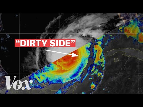
VoiceTube が 2024 年 10 月 21 日 に投稿ハリケーンの「危険な側面」について、疑問に思ったことはありませんか?この解説動画では、高潮や進路予測の「uncertainty cone」といった重要用語を解説しながら、嵐の危険な領域に迫ります。この動画を見れば、ハリケーンの影響に関する実践的な知識と、さらに高度な語彙が身につくはずです!
この動画をアプリで学ぼう!
VoiceTubeアプリ版なら、効果的な学習機能がもっと充実しています!